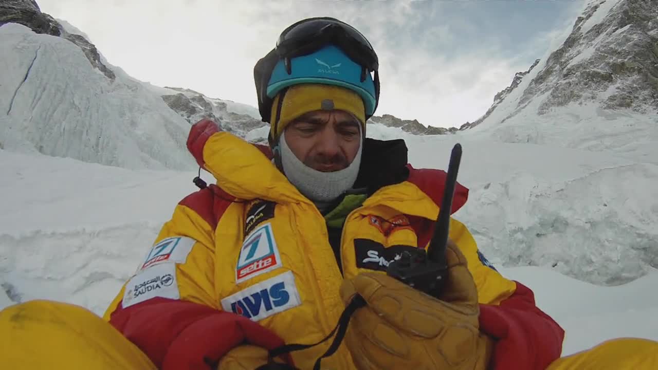
{"video":[],"contents":[{"id":"wk-0","pos":{"top":5,"left":96},"time":{"start":139,"end":168},"art":"Nanga Parbat","lang":"en","wiki":"<div style=\"float:left;margin-right:10px\"><img src=\"http://upload.wikimedia.org/wikipedia/commons/thumb/2/29/Nanga_Parbat_The_Killer_Mountain.jpg/280px-Nanga_Parbat_The_Killer_Mountain.jpg\"></div><br><div>\n<p><b>Nanga Parbat</b> (literally, <i>Naked Mountain</i> ; Hindi: नंगा पर्बत ; Urdu: <span class=\"Nastaliq\" title=\"Nastaliq\" style=\"font-size: 125%; font-family: 'Jameel Noori Nastaleeq', 'Urdu Typesetting', 'Noto Nastaliq Urdu', 'Noto Nastaliq Urdu Draft', 'Hussaini Nastaleeq', 'AlQalam Taj Nastaleeq', IranNastaliq, 'Nafees Nastaleeq', 'Nafees Nastaleeq v1.01', Nafees, 'Pak Nastaleeq', 'PDMS_Jauhar', 'Alvi Lahori Nastaleeq';\">ننگا پربت</span> <span title=\"Representation in the International Phonetic Alphabet (IPA)\" class=\"IPA\">[nəŋɡaː pərbət̪]</span>) is the ninth highest mountain in the world at 8,126 metres (26,660 ft) above sea level. It is the western anchor of the Himalayas around which the Indus river skirts into the plains of Pakistan. It is located in the Gilgit-Baltistan region of the Pakistan and is locally known as 'Deo Mir' ('देओ मीर')('mir' meaning 'mountain').</p>\n<p>Nanga Parbat is one of the eight-thousanders, with a summit elevation of 8,126 metres (26,660 ft). An immense, dramatic peak rising far above its surrounding terrain, Nanga Parbat is also a notoriously difficult climb. Numerous mountaineering deaths in the mid and early 20th century lent it the nickname \"killer mountain\".</p>\n\n\n\n<!-- \nNewPP limit report\nParsed by mw1194\nCached time: 20160309152210\nCache expiry: 2592000\nDynamic content: false\nCPU time usage: 0.295 seconds\nReal time usage: 0.367 seconds\nPreprocessor visited node count: 1732/1000000\nPreprocessor generated node count: 0/1500000\nPost‐expand include size: 34193/2097152 bytes\nTemplate argument size: 2157/2097152 bytes\nHighest expansion depth: 22/40\nExpensive parser function count: 4/500\nLua time usage: 0.151/10.000 seconds\nLua memory usage: 4.47 MB/50 MB\nNumber of Wikibase entities loaded: 1-->\n\n<!-- \nTransclusion expansion time report (%,ms,calls,template)\n100.00% 352.936 1 - -total\n 77.76% 274.429 1 - Template:Infobox_mountain\n 73.43% 259.173 1 - Template:Infobox\n 17.07% 60.254 1 - Template:Infobox_coord\n 16.43% 57.973 3 - Template:Convinfobox\n 15.33% 54.090 1 - Template:Coord\n 14.81% 52.266 4 - Template:Convert\n 14.80% 52.250 2 - Template:Convinfobox/pri2\n 12.32% 43.493 1 - Template:Infobox_map\n 11.51% 40.612 2 - Template:Cite_web\n-->\n</div><a href=\"http://en.wikipedia.org/wiki/Nanga Parbat\" target=\"_blank\">Continua a leggere..</a>","title":"Nanga Parbat"},{"id":"wk-0","pos":{"top":5,"left":96},"time":{"start":139,"end":169},"art":"Nanga Parbat","lang":"en","wiki":"<div style=\"float:left;margin-right:10px\"><img src=\"http://upload.wikimedia.org/wikipedia/commons/thumb/2/29/Nanga_Parbat_The_Killer_Mountain.jpg/280px-Nanga_Parbat_The_Killer_Mountain.jpg\"></div><br><div>\n<p><b>Nanga Parbat</b> (literally, <i>Naked Mountain</i> ; Hindi: नंगा पर्बत ; Urdu: <span class=\"Nastaliq\" title=\"Nastaliq\" style=\"font-size: 125%; font-family: 'Jameel Noori Nastaleeq', 'Urdu Typesetting', 'Noto Nastaliq Urdu', 'Noto Nastaliq Urdu Draft', 'Hussaini Nastaleeq', 'AlQalam Taj Nastaleeq', IranNastaliq, 'Nafees Nastaleeq', 'Nafees Nastaleeq v1.01', Nafees, 'Pak Nastaleeq', 'PDMS_Jauhar', 'Alvi Lahori Nastaleeq';\">ننگا پربت</span> <span title=\"Representation in the International Phonetic Alphabet (IPA)\" class=\"IPA\">[nəŋɡaː pərbət̪]</span>) is the ninth highest mountain in the world at 8,126 metres (26,660 ft) above sea level. It is the western anchor of the Himalayas around which the Indus river skirts into the plains of Pakistan. It is located in the Gilgit-Baltistan region of the Pakistan and is locally known as 'Deo Mir' ('देओ मीर')('mir' meaning 'mountain').</p>\n<p>Nanga Parbat is one of the eight-thousanders, with a summit elevation of 8,126 metres (26,660 ft). An immense, dramatic peak rising far above its surrounding terrain, Nanga Parbat is also a notoriously difficult climb. Numerous mountaineering deaths in the mid and early 20th century lent it the nickname \"killer mountain\".</p>\n\n\n\n<!-- \nNewPP limit report\nParsed by mw1202\nCached time: 20160308145856\nCache expiry: 2592000\nDynamic content: false\nCPU time usage: 0.260 seconds\nReal time usage: 0.331 seconds\nPreprocessor visited node count: 1732/1000000\nPreprocessor generated node count: 0/1500000\nPost‐expand include size: 34193/2097152 bytes\nTemplate argument size: 2157/2097152 bytes\nHighest expansion depth: 22/40\nExpensive parser function count: 4/500\nLua time usage: 0.130/10.000 seconds\nLua memory usage: 4.47 MB/50 MB\nNumber of Wikibase entities loaded: 1-->\n\n<!-- \nTransclusion expansion time report (%,ms,calls,template)\n100.00% 317.676 1 - -total\n 75.18% 238.817 1 - Template:Infobox_mountain\n 69.94% 222.181 1 - Template:Infobox\n 15.97% 50.748 3 - Template:Convinfobox\n 13.91% 44.175 1 - Template:Infobox_coord\n 13.58% 43.145 2 - Template:Cite_web\n 13.17% 41.846 2 - Template:Convinfobox/pri2\n 13.10% 41.608 4 - Template:Convert\n 12.35% 39.222 1 - Template:Coord\n 10.00% 31.774 1 - Template:Infobox_map\n-->\n</div><a href=\"http://en.wikipedia.org/wiki/Nanga Parbat\" target=\"_blank\">Continua a leggere..</a>","title":"Nanga Parbat"},{"id":"wk-0","pos":{"top":5,"left":96},"time":{"start":139,"end":168},"art":"Nanga Parbat","lang":"en","wiki":"<div style=\"float:left;margin-right:10px\"><img src=\"http://upload.wikimedia.org/wikipedia/commons/thumb/2/29/Nanga_Parbat_The_Killer_Mountain.jpg/280px-Nanga_Parbat_The_Killer_Mountain.jpg\"></div><br><div>\n<p><b>Nanga Parbat</b> (literally, <i>Naked Mountain</i> ; Hindi: नंगा पर्बत ; Urdu: <span class=\"Nastaliq\" title=\"Nastaliq\" style=\"font-size: 125%; font-family: 'Jameel Noori Nastaleeq', 'Urdu Typesetting', 'Noto Nastaliq Urdu', 'Noto Nastaliq Urdu Draft', 'Hussaini Nastaleeq', 'AlQalam Taj Nastaleeq', IranNastaliq, 'Nafees Nastaleeq', 'Nafees Nastaleeq v1.01', Nafees, 'Pak Nastaleeq', 'PDMS_Jauhar', 'Alvi Lahori Nastaleeq';\">ننگا پربت</span> <span title=\"Representation in the International Phonetic Alphabet (IPA)\" class=\"IPA\">[nəŋɡaː pərbət̪]</span>) is the ninth highest mountain in the world at 8,126 metres (26,660 ft) above sea level. It is the western anchor of the Himalayas around which the Indus river skirts into the plains of Pakistan. It is located in the Gilgit-Baltistan region of the Pakistan and is locally known as 'Deo Mir' ('देओ मीर')('mir' meaning 'mountain').</p>\n<p>Nanga Parbat is one of the eight-thousanders, with a summit elevation of 8,126 metres (26,660 ft). An immense, dramatic peak rising far above its surrounding terrain, Nanga Parbat is also a notoriously difficult climb. Numerous mountaineering deaths in the mid and early 20th century lent it the nickname \"killer mountain\".</p>\n\n\n\n<!-- \nNewPP limit report\nParsed by mw1194\nCached time: 20160309152210\nCache expiry: 2592000\nDynamic content: false\nCPU time usage: 0.295 seconds\nReal time usage: 0.367 seconds\nPreprocessor visited node count: 1732/1000000\nPreprocessor generated node count: 0/1500000\nPost‐expand include size: 34193/2097152 bytes\nTemplate argument size: 2157/2097152 bytes\nHighest expansion depth: 22/40\nExpensive parser function count: 4/500\nLua time usage: 0.151/10.000 seconds\nLua memory usage: 4.47 MB/50 MB\nNumber of Wikibase entities loaded: 1-->\n\n<!-- \nTransclusion expansion time report (%,ms,calls,template)\n100.00% 352.936 1 - -total\n 77.76% 274.429 1 - Template:Infobox_mountain\n 73.43% 259.173 1 - Template:Infobox\n 17.07% 60.254 1 - Template:Infobox_coord\n 16.43% 57.973 3 - Template:Convinfobox\n 15.33% 54.090 1 - Template:Coord\n 14.81% 52.266 4 - Template:Convert\n 14.80% 52.250 2 - Template:Convinfobox/pri2\n 12.32% 43.493 1 - Template:Infobox_map\n 11.51% 40.612 2 - Template:Cite_web\n-->\n</div><a href=\"http://en.wikipedia.org/wiki/Nanga Parbat\" target=\"_blank\">Continua a leggere..</a>","title":"Nanga Parbat"},{"id":"wk-0","pos":{"top":5,"left":96},"time":{"start":139,"end":169},"art":"Nanga Parbat","lang":"en","wiki":"<div style=\"float:left;margin-right:10px\"><img src=\"http://upload.wikimedia.org/wikipedia/commons/thumb/2/29/Nanga_Parbat_The_Killer_Mountain.jpg/280px-Nanga_Parbat_The_Killer_Mountain.jpg\"></div><br><div>\n<p><b>Nanga Parbat</b> (literally, <i>Naked Mountain</i> ; Hindi: नंगा पर्बत ; Urdu: <span class=\"Nastaliq\" title=\"Nastaliq\" style=\"font-size: 125%; font-family: 'Jameel Noori Nastaleeq', 'Urdu Typesetting', 'Noto Nastaliq Urdu', 'Noto Nastaliq Urdu Draft', 'Hussaini Nastaleeq', 'AlQalam Taj Nastaleeq', IranNastaliq, 'Nafees Nastaleeq', 'Nafees Nastaleeq v1.01', Nafees, 'Pak Nastaleeq', 'PDMS_Jauhar', 'Alvi Lahori Nastaleeq';\">ننگا پربت</span> <span title=\"Representation in the International Phonetic Alphabet (IPA)\" class=\"IPA\">[nəŋɡaː pərbət̪]</span>) is the ninth highest mountain in the world at 8,126 metres (26,660 ft) above sea level. It is the western anchor of the Himalayas around which the Indus river skirts into the plains of Pakistan. It is located in the Gilgit-Baltistan region of the Pakistan and is locally known as 'Deo Mir' ('देओ मीर')('mir' meaning 'mountain').</p>\n<p>Nanga Parbat is one of the eight-thousanders, with a summit elevation of 8,126 metres (26,660 ft). An immense, dramatic peak rising far above its surrounding terrain, Nanga Parbat is also a notoriously difficult climb. Numerous mountaineering deaths in the mid and early 20th century lent it the nickname \"killer mountain\".</p>\n\n\n\n<!-- \nNewPP limit report\nParsed by mw1202\nCached time: 20160308145856\nCache expiry: 2592000\nDynamic content: false\nCPU time usage: 0.260 seconds\nReal time usage: 0.331 seconds\nPreprocessor visited node count: 1732/1000000\nPreprocessor generated node count: 0/1500000\nPost‐expand include size: 34193/2097152 bytes\nTemplate argument size: 2157/2097152 bytes\nHighest expansion depth: 22/40\nExpensive parser function count: 4/500\nLua time usage: 0.130/10.000 seconds\nLua memory usage: 4.47 MB/50 MB\nNumber of Wikibase entities loaded: 1-->\n\n<!-- \nTransclusion expansion time report (%,ms,calls,template)\n100.00% 317.676 1 - -total\n 75.18% 238.817 1 - Template:Infobox_mountain\n 69.94% 222.181 1 - Template:Infobox\n 15.97% 50.748 3 - Template:Convinfobox\n 13.91% 44.175 1 - Template:Infobox_coord\n 13.58% 43.145 2 - Template:Cite_web\n 13.17% 41.846 2 - Template:Convinfobox/pri2\n 13.10% 41.608 4 - Template:Convert\n 12.35% 39.222 1 - Template:Coord\n 10.00% 31.774 1 - Template:Infobox_map\n-->\n</div><a href=\"http://en.wikipedia.org/wiki/Nanga Parbat\" target=\"_blank\">Continua a leggere..</a>","title":"Nanga Parbat"},{"id":"wk-4","pos":{"top":5,"left":96},"time":{"start":191,"end":221},"art":"Albert Frederick Mummery","lang":"en","wiki":"<div style=\"float:left;margin-right:10px\"><img src=\"http:null\"></div><br><div>\n\n<!-- \nNewPP limit report\nParsed by mw1130\nCached time: 20160309162108\nCache expiry: 2592000\nDynamic content: false\nCPU time usage: 0.000 seconds\nReal time usage: 0.001 seconds\nPreprocessor visited node count: 0/1000000\nPreprocessor generated node count: 0/1500000\nPost‐expand include size: 0/2097152 bytes\nTemplate argument size: 0/2097152 bytes\nHighest expansion depth: 0/40\nExpensive parser function count: 0/500\nNumber of Wikibase entities loaded: 0-->\n\n<!-- \nTransclusion expansion time report (%,ms,calls,template)\n100.00% 0.000 1 - -total\n-->\n</div><a href=\"http://en.wikipedia.org/wiki/Albert Frederick Mummery\" target=\"_blank\">Continua a leggere..</a>","title":"Albert Frederick Mummery"},{"id":"wk-5","pos":{"top":5,"left":96},"time":{"start":305,"end":335},"art":"Indus River","lang":"en","wiki":"<div style=\"float:left;margin-right:10px\"><img src=\"http://upload.wikimedia.org/wikipedia/commons/thumb/b/bb/Indus.A2002274.0610.1km.jpg/240px-Indus.A2002274.0610.1km.jpg\"></div><br><div>\n\n\n<p>The <b>Sindhu River</b>, also called the <b>Indus River</b>, or <b>Abāsīn</b>, is a major south-flowing river in South Asia. The total length of the river is 3,180 km (1,980 mi) which makes it one of longest rivers in Asia. It flows through Pakistan, the Indian state of Jammu and Kashmir and western Tibet. Originating in the Tibetan Plateau in the vicinity of Lake Mansarovar, the river runs a course through the Ladakh region of Jammu and Kashmir, towards Gilgit-Baltistan and then flows in a southerly direction along the entire length of Punjab, Pakistan to merge into the Arabian Sea near the port city of Karachi in Sindh. It is the longest river of Pakistan.</p>\n<p>The river has a total drainage area exceeding 1,165,000 km (450,000 sq mi). Its estimated annual flow stands at around 207 km (50 cu mi), making it the twenty-first largest river in the world in terms of annual flow. The Zanskar is its left bank tributary in Ladakh. In the plains, its left bank tributary is the Chenab which itself has four major tributaries, namely, the Jhelum, the Ravi, the Beas and the Sutlej. Its principal right bank tributaries are the Shyok, the Gilgit, the Kabul, the Gomal and the Kurram. Beginning in a mountain spring and fed with glaciers and rivers in the Himalayas, the river supports ecosystems of temperate forests, plains and arid countryside.</p>\n<p>The Sindhu forms the delta of present-day Pakistan mentioned in the Vedic Rigveda as <i>Sapta Sindhu</i> and the Iranian Zend Avesta as <i>Hapta Hindu</i> (both terms meaning \"seven rivers\"). The river has been a source of wonder since the Classical Period, with King Darius of Persia sending his Greek subject Scylax of Caryanda to explore the river as early as 510 BC.</p>\n\n\n<!-- \nNewPP limit report\nParsed by mw1231\nCached time: 20160309162412\nCache expiry: 2592000\nDynamic content: false\nCPU time usage: 0.293 seconds\nReal time usage: 0.371 seconds\nPreprocessor visited node count: 3202/1000000\nPreprocessor generated node count: 0/1500000\nPost‐expand include size: 42710/2097152 bytes\nTemplate argument size: 9530/2097152 bytes\nHighest expansion depth: 24/40\nExpensive parser function count: 23/500\nLua time usage: 0.052/10.000 seconds\nLua memory usage: 2.48 MB/50 MB\nNumber of Wikibase entities loaded: 1-->\n\n<!-- \nTransclusion expansion time report (%,ms,calls,template)\n100.00% 331.638 1 - -total\n 75.21% 249.410 1 - Template:Geobox\n 16.87% 55.960 1 - Template:Geobox2_coor\n 15.28% 50.685 1 - Template:Coord\n 10.83% 35.927 3 - Template:Convert\n 9.97% 33.069 4 - Template:Geobox2_list\n 7.32% 24.272 4 - Template:Geobox2_unit\n 6.34% 21.014 1 - Template:Redirect4\n 5.83% 19.323 1 - Template:Use_dmy_dates\n 5.75% 19.078 1 - Template:Geobox2_coor_type\n-->\n</div><a href=\"http://en.wikipedia.org/wiki/Indus River\" target=\"_blank\">Continua a leggere..</a>","title":"Indus River"},{"id":"tx-6","pos":{"top":5,"left":96},"time":{"start":351.1,"end":381.1},"title":"","text":"<p>Three days of splendid sun, on one of them making the trail in the snow, crusty slabs are breaking and making dull noises. We’re shivering while our protection attached on the slope to the glacier is crumbling under our feet. One, two, three avalanches, one traverses the glacier and arrives at the base camp. We are not there, we’re in the snow, then we see the tents shivering, and go on. “Too dangerous even if these are summit days” and we’re worried about the Polish at a height of 7000m at the Mazeno pass. “If he, as he said, descends here, he’ll find a lot of fucking snow…” then no other news...</p>\n\n<p><a href=\"http://www.mountainblog.it/danielenardi/?tag=elisabeth-revol&lang=en\" target=\"_blank\">Continue...</a></p>\n"},{"id":"wk-7","pos":{"top":5,"left":96},"time":{"start":482,"end":512},"art":"Daniele Nardi","lang":"it","wiki":"<div>\n<p><b>Daniele Nardi</b> (Sezze, 24 giugno 1976) è un alpinista italiano.</p>\n<p>Ha al suo attivo cinque Ottomila <span title=\"Il testo selezionato deve essere comprovato da una fonte affidabile. Modifica la pagina per aggiungere fonti.\" style=\"background:#ffeaea; color:#444444\">ed è stato il primo alpinista a conquistare lo Sperone Mummery (6.450 metri) del Nanga Parbat in inverno nel febbraio 2013.</span></p>\n\n\n<!-- \nNewPP limit report\nParsed by mw1115\nCached time: 20160309163053\nCache expiry: 2592000\nDynamic content: false\nCPU time usage: 0.099 seconds\nReal time usage: 0.129 seconds\nPreprocessor visited node count: 298/1000000\nPreprocessor generated node count: 0/1500000\nPost‐expand include size: 7862/2097152 bytes\nTemplate argument size: 3926/2097152 bytes\nHighest expansion depth: 12/40\nExpensive parser function count: 11/500\nLua time usage: 0.050/10.000 seconds\nLua memory usage: 1.46 MB/50 MB\nNumber of Wikibase entities loaded: 1-->\n\n<!-- \nTransclusion expansion time report (%,ms,calls,template)\n100.00% 115.459 1 - -total\n 56.02% 64.682 1 - Template:Bio\n 39.77% 45.917 1 - Template:E\n 37.13% 42.872 1 - Template:Avviso\n 21.20% 24.475 1 - Template:Tl\n 6.72% 7.762 1 - Template:Categorie_avviso\n 4.01% 4.626 1 - Template:Citazione_necessaria\n 2.68% 3.090 1 - Template:Icona_lavoro\n 2.12% 2.443 1 - Template:Argomenti_avviso\n 2.11% 2.435 1 - Template:Chiarimento\n-->\n</div><a href=\"http://it.wikipedia.org/wiki/Daniele Nardi\" target=\"_blank\">Continua a leggere..</a>","title":"Daniele Nardi"},{"id":"wk-8","pos":{"top":5,"left":96},"time":{"start":679,"end":709},"art":"2013 Nanga Parbat massacre","lang":"en","wiki":"<div style=\"float:left;margin-right:10px\"><img src=\"http://upload.wikimedia.org/wikipedia/commons/thumb/6/66/Pakistan_location_map.svg/250px-Pakistan_location_map.svg.png\"></div><br><div>\n\n<p>On June 22, 2013, about 16 militants, reportedly dressed in Gilgit Scouts uniforms, stormed a high-altitude mountaineering base camp in Gilgit–Baltistan, Pakistan, and killed 10 climbers and a local guide. The climbers were from various countries, including Ukraine, China, Slovakia, Lithuania and Nepal. A Chinese citizen managed to escape the assailants, and a member of the group from Latvia happened to be outside the camp during the attack. The attack happened at the base camp on Nanga Parbat, the ninth highest mountain in the world. The mountain is popular among trekkers and mountaineers from June to August because of the moderate weather conditions.</p>\n<p>In November 2013, many of the assailants involved in the attack were arrested and tried under the Anti-Terrorist Act. According to the Senate's Standing Committee on Foreign Relations, the original motive of the militants had not been to kill the tourists, but kidnap them for ransom.</p>\n\n\n\n<!-- \nNewPP limit report\nParsed by mw1122\nCached time: 20160309163805\nCache expiry: 2592000\nDynamic content: false\nCPU time usage: 0.362 seconds\nReal time usage: 0.424 seconds\nPreprocessor visited node count: 1694/1000000\nPreprocessor generated node count: 0/1500000\nPost‐expand include size: 79900/2097152 bytes\nTemplate argument size: 11960/2097152 bytes\nHighest expansion depth: 17/40\nExpensive parser function count: 2/500\nLua time usage: 0.146/10.000 seconds\nLua memory usage: 3.09 MB/50 MB\nNumber of Wikibase entities loaded: 0-->\n\n<!-- \nTransclusion expansion time report (%,ms,calls,template)\n100.00% 375.898 1 - -total\n 29.31% 110.184 1 - Template:Infobox_civilian_attack\n 27.58% 103.690 1 - Template:Infobox\n 23.99% 90.191 6 - Template:Broken_ref\n 16.63% 62.507 3 - Template:Cite_news\n 15.68% 58.923 1 - Template:Pakistan_terrorist_attacks\n 13.73% 51.616 1 - Template:Military_navigation\n 12.01% 45.149 1 - Template:Navbox\n 5.52% 20.764 1 - Template:Location_map\n 4.75% 17.851 5 - Template:WPMILHIST_Infobox_style\n-->\n</div><a href=\"http://en.wikipedia.org/wiki/2013 Nanga Parbat massacre\" target=\"_blank\">Continua a leggere..</a>","title":"2013 Nanga Parbat massacre"},{"id":"tx-9","pos":{"top":5,"left":96},"time":{"start":948,"end":978},"title":"Nanga Parbat: End of Tomek Mackiewicz’ Fifth Winter Attempt","text":"<p>(By Raheel Adnan) Tomek Mackiewicz’ Fifth attempt on Nanga Parbat ends here, as he suffers a broken rib and fractured leg after a snow bridge at around 6500m broke, causing the Polish climber to fall 50 meters into a crevasse. The accident happened when he was descending after summit push, together with Elisabeth Revol.</p>\n\n<p><a href=\"http://www.explorersweb.com/everest_k2/news.php?url=nanga-parbat-end-of-tomek-mackiewicz-fif_142169449\" target=\"_blank\">Continue...</a></p>\n","lang":"en"},{"id":"wk-10","pos":{"top":5,"left":96},"time":{"start":1257,"end":1287},"art":"Serac","lang":"en","wiki":"<div>\n\n\n<p>A <b>serac</b> (originally from Swiss French <i>sérac</i>) is a block or column of glacial ice, often formed by intersecting crevasses on a glacier. Commonly house-sized or larger, they are dangerous to mountaineers since they may topple with little warning. Even when stabilized by persistent cold weather, they can be an impediment to glacier travel.</p>\n<p>Seracs are found within an icefall, often in large numbers, or on ice faces on the lower edge of a hanging glacier. Examples of the latter in the Alps are found on the northeast face of Piz Roseg, the north face of the Dent d'Hérens, and the north face of Lyskamm. They are well-known obstacles on many of the world's highest mountains, Kanchenjunga (located on the border of India and Nepal) in particular. The collapse of large seracs was responsible for at least 8 of the 11 deaths of the August 2008 climbing accident on K2. In April 2014, a large serac broke off and caused an avalanche on Mount Everest, which was responsible for the death of 16 climbers.</p>\n\n\n\n<!-- \nNewPP limit report\nParsed by mw1135\nCached time: 20160309164230\nCache expiry: 2592000\nDynamic content: false\nCPU time usage: 0.129 seconds\nReal time usage: 0.164 seconds\nPreprocessor visited node count: 182/1000000\nPreprocessor generated node count: 0/1500000\nPost‐expand include size: 6775/2097152 bytes\nTemplate argument size: 108/2097152 bytes\nHighest expansion depth: 6/40\nExpensive parser function count: 1/500\nLua time usage: 0.063/10.000 seconds\nLua memory usage: 1.61 MB/50 MB\nNumber of Wikibase entities loaded: 0-->\n\n<!-- \nTransclusion expansion time report (%,ms,calls,template)\n100.00% 150.285 1 - -total\n 28.90% 43.432 1 - Template:Refimprove\n 28.75% 43.209 1 - Template:Cite_book\n 26.13% 39.264 2 - Template:For\n 24.27% 36.468 1 - Template:Ambox\n 23.88% 35.895 2 - Template:Hatnote\n 5.29% 7.954 1 - Template:Cite_news\n-->\n</div><a href=\"http://en.wikipedia.org/wiki/Serac\" target=\"_blank\">Continua a leggere..</a>","title":"Serac"},{"id":"tx-11","pos":{"top":5,"left":96},"time":{"start":3013,"end":3043},"title":"ALEX TXIKON","text":"<p>Born in Lemoa (Bizkaia, Basque Country), on 12th of December 1981, Alex Txikon is the youngest of 13 brothers and sisters. When he was no more than 3 years old, his brother Javi, the one who taught him to love mountaineering, took Alex to the top of Gorbea mountain, one of the most emblematic peaks in Basque Country. He joined Ganzabal Mountain Club at teenage and could try himslelf in Pyrenees, Picos de Europa and Alps for the first time. In his 17 travelled to Pamir Mountains and he was just 21 when reached the summit of his first +8.000m mountain: Broad Peak (8.051m) in Pakistan.</p>\n\n<p><a href=\"http://alextxikon.com/en/my-life/\" target=\"_blank\">Continue...</a></p>\n"},{"id":"tx-12","pos":{"top":5,"left":96},"time":{"start":3174,"end":3204},"title":"ALI SADPARA","text":"<h2>Ali ‘Sadpara’: “My work is always invisible”</h2>\n\n<p>Muhammad Ali ‘Sadpara’ (Sadpara, 1977) is, nowadays, the strongest climber in Pakistan. He’s reached the top of four of the five ‘8 thousands’ in this country (Broad Peak, Nanga Parbat, G1 and G2; K2 left) and made some other important climbing activities that deserve appreciation: in 2006 he reached, alone, Spantik (7.027m) summit after opening a new route; in 2008 and 2010 winters he fixed Broad Peak route up to C3 for the polish team; and did so in 2012 winter in G1: equipped Japanese Couloir from C2 to C3.</p>\n\n<p><a href=\"http://alextxikon.com/en/ali-sadpara-my-work-is-always-invisible/\" target=\"_blank\">Continue...</a></p>\n"},{"id":"wk-13","pos":{"top":5,"left":96},"time":{"start":4290,"end":4320},"art":"Jerzy Kukuczka","lang":"en","wiki":"<div style=\"float:left;margin-right:10px\"><img src=\"http://upload.wikimedia.org/wikipedia/commons/thumb/2/2f/Jerzy_Kukuczka_Mount_Everest_1980.jpg/220px-Jerzy_Kukuczka_Mount_Everest_1980.jpg\"></div><br><div>\n\n<p><b>Jerzy Kukuczka</b> (24 March 1948 in Katowice, Poland – 24 October 1989 Lhotse, Nepal) was a Polish alpine and high-altitude climber. Born in Katowice, his family origin is Goral. On 18 September 1987, he became the second man, after Reinhold Messner, to climb all fourteen eight-thousanders in the world. He is the first man who made the first winter ascents of three eight-thousanders: Dhaulagiri with Andrzej Czok in 1985, Kangchenjunga with Krzysztof Wielicki in 1986 and Annapurna I with Artur Hajzer in 1987. He is the only climber to have ascended four of the eight-thousanders during winter. Along with Tadeusz Piotrowski, Kukuczka established a new route on K2 (the so-called \"Polish Line\"), which no one has ever repeated.</p>\n\n\n<!-- \nNewPP limit report\nParsed by mw1140\nCached time: 20160309164752\nCache expiry: 86400\nDynamic content: true\nCPU time usage: 0.175 seconds\nReal time usage: 0.238 seconds\nPreprocessor visited node count: 1188/1000000\nPreprocessor generated node count: 0/1500000\nPost‐expand include size: 6021/2097152 bytes\nTemplate argument size: 1834/2097152 bytes\nHighest expansion depth: 16/40\nExpensive parser function count: 0/500\nLua time usage: 0.053/10.000 seconds\nLua memory usage: 1.19 MB/50 MB\nNumber of Wikibase entities loaded: 1-->\n\n<!-- \nTransclusion expansion time report (%,ms,calls,template)\n100.00% 208.764 1 - Template:Infobox_person\n100.00% 208.764 1 - -total\n 75.21% 157.012 1 - Template:Infobox\n 33.31% 69.549 5 - Template:Br_separated_entries\n 11.97% 24.985 1 - Template:Wikidata_image\n 7.86% 16.419 1 - Template:Birth_date\n 7.60% 15.856 2 - Template:Flagicon\n 5.80% 12.105 1 - Template:Death_date_and_age\n 3.76% 7.844 1 - Template:Unbulleted_list\n 3.76% 7.843 4 - Template:MONTHNUMBER\n-->\n</div><a href=\"http://en.wikipedia.org/wiki/Jerzy Kukuczka\" target=\"_blank\">Continua a leggere..</a>","title":"Jerzy Kukuczka"}]}
In questa area puoi vedere i video che pensiamo possano interessarti, scelti in funzione dei video che hai visto precedentemente o delle preferenze che hai espresso.
Per accedere a questa area registrati.
registrati
Le tue playlist
In questa area puoi vedere tutti i video che hai memorizzato e che ti sono piaciuti e puoi creare playlist personali.
Per accedere a questa area registrati.
Realizzato grazie al contributo del POR FESR Regione Lazio 2007-2013 – Asse I – Avviso Pubblico "Insieme x Vincere" – Prot. Domanda
n.SVLAZ-SU-2012-1038 – Codice CUP n. F84E14000930007 e Avviso pubblico per la presentazione di progetti di innovazione delle micro e piccole imprese - Prot.
FILAS-MI-2011-1343 del 3/8/2012 – CUP F87I1200233007